The panorama photographs on this page were made using a Canon Digital Ixus 400, a handy 4 megapixel digital pocket camera also known as the "Digital Elph" in the USA, while those after March 2008 were made with a Canon Digital Ixus 75.
Individual pictures were combined into these panorama images using the open source software Hugin as the frontend software GUI with PTStitcher as the stitching engine. Some after-editing of the images was done in Photoshop: mainly cropping, resizing and some colour and shadow/highlight corrections.
(Note: to view the pictures geolocated on Google Maps, go to my page on Panoramio. Location information is also in the image EXIF.
Several of these images are also visible directly in Google Earth at the spot where they were taken by activating the "Geographic web" layer.
For recent single-shot images of other scenic spots and some macro images, see this slideshow)
")
The central train and bus station of Leiden, the Netherlands (for a larger version, click here). This panorama was created on 2007 March 10 from 16 wide angle photographs.The horizontal angle of the panorama equals about 230 degrees.

The 1667 AD Zijlpoort (Zijlgate), one of two remaining town gates at Leiden, the Netherlands, as viewed from the Ankerpark (for a larger version, click here). The canon in the foreground is from 1819 AD. This panorama was created in the afternoon of 30 September 2007 from 3 wide angle photographs.The horizontal angle of the panorama equals about 115 degrees.

The 1669 AD Morschpoort (Morschgate), one of two remaining town gates at Leiden, the Netherlands, as viewed from the Morssingel (for a larger version, click here). At right is windmill "De Put", at left a glimpse of the National Museum of Ethnography. This panorama was created in the afternoon of 22 October 2007 from 7 wide angle photographs.The horizontal angle of the panorama equals about 170 degrees.

Three 17th century windmills in their polder landscape setting near Stompwijk, the Netherlands (for a larger version, click here). The windmills were built in 1672 AD to drain a lake and turn it into polder. This panorama was created on 2007 July 28 from 5 wide angle photographs.The horizontal angle of the panorama equals about 135 degrees.

Het Galgenwater (actually a part of the Rhine) in Leiden, The Netherlands, as seen from the other end (see above), the Rembrandtbrug and windmill "Molen de Put". The location from which this was shot is some 25 yards from the birthplace of Rembrandt. This panorama was created on 2007 February 3 from five adjacent wide angle photographs. The horizontal angle of the panorama equals about 160 degrees (for a larger version, click here).

Het Rapenburg (one of the main medieval canals) in Leiden, The Netherlands, as seen from opposite the Dutch National Antiquities Museum. This panorama was created on 2007 February 4 from eight adjacent wide angle photographs. It was shot without the use of a tripod, just before sunset. The horizontal angle of the panorama equals about 180 degrees (for a larger version, click
here).

Het Gravensteen (Earl's stronghold) on Het Gerecht ("The Court") in the center of Leiden dates to the 13th century. It was the medieval Court of Justice of the Earls of Holland (and later the city of Leiden), and on the square in front of it (Het Gerecht) those condemned by the Court faced their execution.This panorama was created in the morning of 5 April 2007 from three adjacent wide angle photographs. The horizontal angle of the panorama equals about 80 degrees.

The Binnenhof ("Inner Court" ) with at left the 13th century Ridderzaal ("Hall of the Knights") in Den Haag (The Hague), the Netherlands. It is the seat of the Dutch Government. This panorama was created in the late afternoon of 7 June 2008 from 12 adjacent wide angle photographs in two layers. The horizontal angle of the panorama equals about 170 degrees (for a larger version click here).

The Nieuwe Rijn (one of the Rhine arms) and Vismarkt in Leiden, the Netherlands, with the Koornbrug in the distance, during wet autumn weather. This small panorama was created in the late afternoon of 13 November 2007 from three adjacent wide angle photographs. The horizontal angle of the panorama equals about 90 degrees (for a larger version, click here).

A 360 degree full circle panorama of the polder landscape at de Wilck between Zoeterwoude and Hazerswoude, the Netherlands. This panorama was created in the afternoon of 2007 August 3 from 12 adjacent photographs. As you can see the country is very flat. This particular part of the polder is 1.7 meter below sea level (for a larger version, click here).

The medieval facade of the Town Hall of Leiden, the Netherlands, at night. Only the facade is still original, as the building completely burned down on 12 February 1929. This panorama was made from 12 images (6 above, 6 below) in the evening of 4 March 2007. The horizontal angle of the panorama equals about 160 degrees. It was a difficult panorama to construct: the building is relatively large (some 100 yards wide and with a high tower) and bordering a relatively narrow street, which means you can not take real distance.

Again the medieval Town Hall of Leiden, but this time in daytime.This panorama was made from 15 images around noon of 25 March 2007. The horizontal angle of the panorama equals about 180 degrees.

De Burcht ("The Castle") is an 11th century Motte-castle in the center of Leiden, the Netherlands. This panorama was created in the afternoon of 2007 January 24 from three adjacent vertically oriented wide angle photographs. The horizontal angle of the panorama equals about 110 degrees.

Overview of the Leiden Culinary Festival, an annually held 4-day festival at the Garenmarkt, Leiden, the Netherlands. This panorama was created in the evening of July 8, 2007, from six adjacent vertically oriented wide angle photographs. The horizontal angle of the panorama equals about 130 degrees

De Burcht ("The Castle") is an 11th century Motte-castle in the center of Leiden, the Netherlands. This view is from the top of the castle wall towards the southeast, and was created from four photographs taken on two separate days. Initially the right part of the image up to the tree trunk was taken, but upon creation of the composite image, I felt the left side was really "missing". Two days later I went back and shot the images that make up that part. I consulted my planetarium software to pick the moment that the sun direction would be most similar. .

Town park "Het Plantsoen" (the side near the Plantage), Leiden, the Netherlands: light and shadow effects due to a low autumn sun. This is a stitch of 2 photographs made in the late afternoon of 30 October 2007.

Polder landscape near Stompwijk, the Netherlands (for a larger version, click here). The surface of this polder is 4.5 meter below sea level. This panorama was created on 2007 July 28 from 5 wide angle photographs.The horizontal angle of the panorama equals about 160 degrees.

Three 17th century windmills along the "Molenpad" near Stompwijk, the Netherlands (for a larger version, click here). The windmills were built in 1672 AD to drain a lake and turn it into polder. This panorama was created on 2007 July 28 from 4 wide angle photographs.The horizontal angle of the panorama equals about 145 degrees.

Christmas illumination of the Nieuwe Rijn (one of the Rhine arms) and Town Hall in Leiden, the Netherlands. This panorama was created in the foggy evening of 19 december 2007 from six wide angle photographs arrangedin two layers. The horizontal angle of the panorama equals about 90 degrees (for a larger version, click here).

Het Galgenwater (actually a part of the Rhine) in Leiden, The Netherlands, as seen from the Borstelbrug. Windmill "Molen de Put" (see also image below) is in the background. This panorama was created on 2007 February 4 from three adjacent wide angle photographs. The horizontal angle of the panorama equals about 90 degrees (for a larger version, click here).

The Beestenmarkt (Animal Market, no longer used for what the name suggests) in Leiden, The Netherlands. The Blauwpoortsbrug at far left, Mill Museum "Molen de Valk" at far right. This panorama was created on 2007 February 3 from six adjacent wide angle photographs. The horizontal angle of the panorama equals about 180 degrees (for a larger version, click here).

The Van der Werff park at the Steenschuur in Leiden, The Netherlands. On 12 January 1807, a vessel loaded with gunpowder moored in this part of the city moat exploded at this spot, killing at least 150 people and flattening the area. In part of the flattened area this park was created. The statue is that of Van der Werff, mayor of the town during the Spanish siege of 1574. This panorama was created on 2007 July 21 from six adjacent wide angle photographs. The horizontal angle of the panorama equals about 170 degrees (for a larger version, click here).

The Stille Rijn ("Silent Rhine") on the confluence of the Oude en Nieuwe Rijn ("Old and New Rhine") in the center of Leiden, the Netherlands. The Hartebrugkerk, a Roman Catholic church build in 1836, is in the background. This panorama was created in the afternoon of 2007 March 19 from three adjacent vertically oriented wide angle photographs. The horizontal angle of the panorama equals about 90 degrees.

The colourful scenery of the bulb flower fields near Hillegom, the Netherlands. This panorama was created in the afternoon of 2007 April 1 from 9 adjacent photographs. The horizontal angle of the panorama equals about 100 degrees (for a larger version, click here).

Polder landscape alongside the "Molenpad" in the Royal Domain "De Horsten" on the border of Wassenaar and Voorschoten, the Netherlands. "De Horsten" are a nature reserve with mixed forest and polder, property of the Queen of the Netherlands. This panorama was created in the afternoon of 2007 May 6 from 6 adjacent photographs. The horizontal angle of the panorama equals about 180 degrees (for a larger version, click here).

The inner courtyard of De Burcht, Leiden, the Netherlands (see also above).This panorama was created on 2007 February 3 from five adjacent wide angle photographs. The horizontal angle of the panorama equals about 150 degrees.

The Witte Singel (Leiden, the Netherlands), seen from opposite the Vlietbrug and the Municipal Archive. The Witte Singel ("white moat") was part of the medieval town fortifications.The horizontal angle of the panorama equals about 110 degrees.
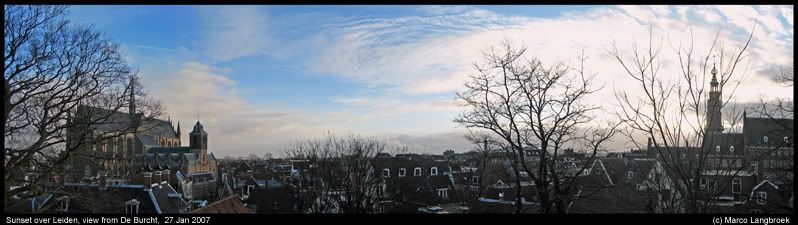
The sun about to set behind the Town Hall of Leiden, the Netherlands. To the left is the Hoogland Church, to the right (with the sun next to it) the tower of the Town Hall. This panorama was created on 2007 January 27 from four adjacent wide angle photographs, taken from the parapet of De Burcht (see below). The horizontal angle of the panorama equals about 140 degrees.
.
| Homepage author | Guestbook author |
| Macro photographs | Slide show other photographs | Time-lapse movie experiments | My page on Panoramio |

